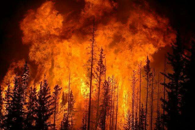

Jakarta, Indonesia Sentinel — Sumatra island are battling with escalating forest and land fires as the dry season takes hold. Satellite data revealing 1,208 hotspots detected across the island, according to the Meteorology, Climatology and Geophysics Agency (BMKG).
Riau Province is currently the hardest hit, accounting for 586 hotspots, nearly half of the total. Other affected regions include North Sumatra (300), West Sumatra (193), South Sumatra (67), Bangka Belitung (55), Jambi (53), Aceh (37), Bengkulu (11), the Riau Islands (4), and Lampung (2).
As of Sunday (July 20), several areas across Sumatra remained surrounded by hotspots linked to ongoing forest and land fires. Here’s the affected areas, as reported by CNN Indonesia
Riau Province
The Pekanbaru branch of Indonesia’s Meteorology, Climatology and Geophysics Agency (BMKG) detected 586 wildfire-related hotspots across Riau Province, according to data updated as of 11:00 p.m. local time on Saturday (July 19).


“The hotspots are spread across ten regencies and cities in Riau,” said BMKG forecaster Anggun R, as quoted by Antara on Sunday (July 20). “Of those, 19 are classified as high-confidence, 34 medium, and 533 low-confidence.”
Rokan Hilir Regency contributed the largest number of hotspots, with 354 detected.
Thick smoke from the fires has significantly reduced visibility at local airports wiht only 4 kilometers at Sultan Syarif Kasim II Airport in Pekanbaru, and as low as 3 kilometers at Japura Airport in Indragiri Hulu.
In Natuna, a fire that broke out Saturday afternoon in Tanjung Sagu, Cemaga, burned more than 30 hectares of land, according to Nurhakim, head of infrastructure and information systems at Natuna’s local fire and disaster management agency. “Initial reports estimated 30 hectares were affected, but with the fire reigniting, the total area burned is now likely higher,” he said.
In a separate incident, a 100-hectare blaze has been burning for five consecutive days in Sei Gajah Induk, Rokan Hilir.
Riau Police Chief Inspector General Herry Heryawan said a joint task force consisting of police, military, and regional disaster management teams is continuing to battle the blazes in several hotspots across the province. Authorities have yet to determine the cause of these wildfires.
West Sumatra
The local government of Solok Regency in West Sumatra is preparing to declare a wildfire emergency following a sharp rise in forest and land fire incidents over the past two months.
Deputy Regent of Solok, Candra, said the emergency status is under consideration due to a notable increase in wildfire cases since May 2025. He expressed concern over more than 100 fire hotspots recorded between May and June, including blazes near Bukit Junjung Sirih and Hiliran Gumanti that nearly threatened residential areas and public facilities.
Citing BMKG forecasts, West Sumatra’s Forestry Department Head Ferdinal Asmin warned that the current dry season is expected to last through September 2025, heightening the wildfire risk.
“We receive daily reports of new hotspots in Solok Regency,” Ferdinal said, noting that budget constraints have limited their operational capacity. “Declaring a state of emergency will improve cross-sector coordination and support.”
He added that most fires continue to be caused by illegal land clearing through burning, a practice that violates environmental laws.
Read Also:
South Sumatra Declares Emergency Alert Status Over Forest and Land Fires
South Sumatra
In South Sumatra, the Regional Disaster Management Agency (BPBD) reported that 10 local governments have declared wildfire alert status.
These include Musi Rawas, Ogan Ilir, Ogan Komering Ilir (OKI), Banyuasin, Musi Banyuasin (Muba), PALI, Lahat, Prabumulih, Muara Enim, and the South Sumatra provincial government.
To bolster firefighting efforts, BPBD South Sumatra received five helicopters on Sunday for wildfire response.
Sudirman, head of emergency response at BPBD South Sumatra, said the aircraft will be deployed for both surveillance and water bombing operations in the event of large-scale fires.
North Sumatra
North Sumatra’s Regional Disaster Management Agency (BPBD) reported a total of 80 wildfire incidents across the province as of July 2025, with the blazes burning an estimated 1,804.95 hectares of land.
According to BPBD Chief Tuahta Ramajaya Saragih, half of the recorded fires occurred within the Lake Toba National Tourism Strategic Area (KSPN), spanning seven regencies.
The remaining 40 incidents were reported outside the Lake Toba region, affecting 14 cities and regencies throughout North Sumatra.


