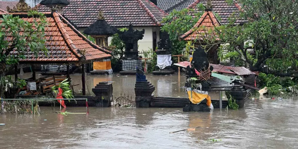

Jakarta, Indonesia Sentinel — The Bali provincial government will begin dismantling structures that obstruct or violate river basin areas (DAS) as part of efforts to prevent a repeated floods in several region across Bali.
Deputy Governor I Nyoman Giri Prasta announced the plan after attending a plenary meeting at the governor’s office in Denpasar on Monday (September 15).
He said authorities would strictly monitor land use to stop arbitrary conversions, particularly on protected rice fields that are barred from development.
“The first principle is to ensure there is no unauthorized change in land use, especially when it involves protected rice fields, which cannot be converted,” he said, as reported by CNN Indonesia.


He added that the administration will also tighten oversight of river basin areas, particularly along the Ayung River, by removing illegal structures and planting trees to improve water absorption.
“We will enforce stricter regulations and expand reforestation as part of our commitment to care for the environment. We have already asked for part of the budget to be allocated for this effort,” Giri Prasta said.
He noted that the province plans to plant more trees, including bamboo, across watershed areas to help absorb rainwater during heavy downpours. Prasta stressed the need for better waterway management from upstream to downstream, warning against blockages or narrowing of existing channels.
Further, Bali Deputy Governor noted that the plan is being discussed with the Bali Regional Legislative Council (DPRD).
“They will definitely be cleared. The process is already underway, and discussions with the DPRD on Bali’s spatial planning (RTW) are part of efforts to conduct field assessments,” Giri Prasta said.
Read Also:
Prabowo Visits Bali After Deadly Floods, Orders Swift Relief Efforts
He added that the government is also coordinating with the Meteorology, Climatology and Geophysics Agency (BMKG) on possible weather modification to mitigate the impact of heavy rainfall.
“We must maintain strong coordination with BMKG, BPBD, and district and city governments to ensure early anticipation of potential disasters,” he said.
Previously, Indonesia’s Environment Minister Hanif Faisol Nurrofiq said river basin landscapes in Bali have changed drastically since 2015, raising concerns over the island’s floods risks.
“Bali’s landscape has shifted, even if not by hundreds or thousands of hectares like in other regions. But here, even small changes matter,” Hanif said during a meeting on flood management with Bali Governor Wayan Koster at the governor’s official residence in Denpasar on Saturday (September 13).
He noted that of Bali’s total 49,500 hectares of watershed areas, only about 3% remains covered by forest or vegetation, far below the ecological minimum of 30%.
“Ecologically, river basins should have at least 30% vegetation to maintain the ecosystem below them,” Hanif explained.
Bali is home to several major river basins, including those flowing from the Ayung River, such as Tukad Mati, Tukad Badung, and Tukad Singapadu. Hanif stressed that the Ayung watershed is particularly critical, as it supports key areas including Denpasar, Badung, Gianyar, and Tabanan.
(Raidi/Agung)


