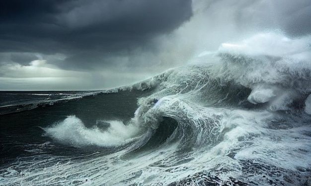

Jakarta, Indonesia Sentinel — The Meteorology, Climatology, and Geophysics Agency (BMKG) has issued an early warning of potentially extreme sea waves reaching up to six meters high, influenced by Tropical Cyclone Taliah in several waters across Indonesia.
Tropical Cyclone Taliah was first detected in the southern Indian Ocean in early February 2025. This tropical cyclone has raised concerns over extreme weather conditions in several parts of Indonesia.
BMKG’s Director of Maritime Meteorology, Eko Prasetyo, stated that Tropical Cyclone Taliah, which has been monitored over the past few days, is located in the Indian Ocean south of Central Java and is moving away from Indonesia. However, its impact has led to increased wind speeds and high waves in several waters across Indonesia.
“The early warning for high sea waves is in effect for three days, from today, February 7, until Monday, February 10,” Prasetyo said on Friday, February 7, as reported by Inilah.com.


Wind patterns in northern Indonesia generally move from northwest to northeast at speeds ranging from 6 to 25 knots, while in the southern region, winds predominantly come from the southwest to northwest at speeds between 6 and 30 knots.
“The highest wind speeds have been observed in the western Indian Ocean off Lampung, the southern Indian Ocean off Java, the southern Indian Ocean off East Nusa Tenggara (NTT), the Flores Sea, and the Arafura Sea,” he noted.
Potential High Waves
According to BMKG, the current conditions has led to an increased wave heights which vary across Indonesian waters. The following is the potential for increased high waves caused by Cyclone Taliah throughout Indonesian waters:
Waves ranging from 1.25 to 2.5 meters are likely to occur in the northern Malacca Strait, the western Indian Ocean off Aceh to Nias, the Karimata Strait, the Java Sea, the Bali Sea, the Sumba Sea, the Flores Sea, the southern Makassar Strait, Bone Bay, the Banda Sea, the eastern Sulawesi Sea, the Maluku Sea, the Seram Sea, the northern, central, and eastern parts of the Arafura Sea, and the northern Pacific Ocean off West Papua to Papua.
Higher waves between 2.5 and 4 meters are expected in the western Indian Ocean off Mentawai to Lampung, the southern Indian Ocean off Banten to West Nusa Tenggara (NTB), the northern Pacific Ocean off Maluku, and the western Arafura Sea.
Very high waves between 4 and 6 meters are predicted in the North Natuna Sea and the southern Indian Ocean off NTT.
Read Also:
Indonesia Weather Alert! Tourist Boats Prohibited to Sail in Labuan Bajo from 1-8 February
Maritime Safety Risks
BMKG’s maritime meteorology team has warned that high waves in several areas pose significant risks to maritime transportation and fishing activities.
As a precaution, fishermen and maritime transport operators, including barges and ferries, are advised to remain vigilant. “Residents living or conducting activities along coastal areas prone to high waves should remain cautious and alert,” Prasetyo emphasized.
As BMKG continues to monitor, Authorities urge the public, especially fishermen and maritime transport operators, to stay informed about weather updates and exercise caution in affected waters. Travelers and coastal communities are advised to take necessary precautions as the high waves persist over the coming days.
(Raidi/Agung)


