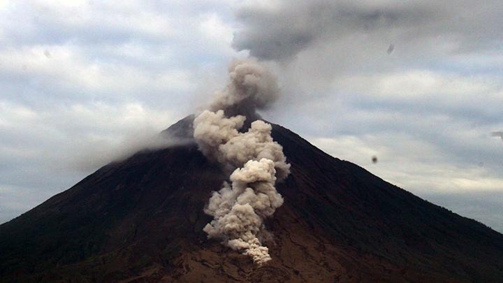

Jakarta, Indonesia Sentinel — Mount Semeru, one of Indonesia’s most active volcanoes, erupted early Tuesday morning, December 17, 2024, at 6:09 AM local time. The eruption released a towering column of volcanic ash reaching 1,000 meters (approximately 3,280 feet) above its summit, according to a report from the Center for Volcanology and Geological Hazard Mitigation (PVMBG).
Mount Semeru, located administratively between Lumajang and Malang regencies in East Java Province, remains at Level II (Alert), signaling ongoing volcanic activity that requires heightened vigilance.
“An eruption occurred on Tuesday, December 17, 2024, at 6:09 AM WIB, with the volcanic ash column observed rising approximately 1,000 meters above the summit (around 4,676 meters above sea level),” stated Mukdas Sofian, an official from the Semeru Volcano Observation Post.
The volcanic ash was reported to be white to gray in color, with thick intensity drifting northeast. Seismic equipment recorded the eruption with a maximum amplitude of 22 mm and a duration of 135 seconds.


Authorities Issue Safety Warnings
Mukdas Sofian urged residents and visitors to avoid specific areas near the volcano due to safety risks associated with volcanic activity. The southeastern sector along the Besuk Kobokan River is particularly hazardous. Authorities have prohibited any activities within a 13-kilometer radius from the summit along this river channel.
Beyond that distance, residents are advised to maintain a safe distance of at least 500 meters from riverbanks along the Besuk Kobokan River, as hot clouds and lava flows could extend up to 17 kilometers from the crater during intensified activity.
“In addition, no activities should occur within a 5-kilometer radius from the crater or summit of Mount Semeru due to the risk of volcanic rocks or incandescent debris being ejected,” Mukdas emphasized.
Risks of Lava Flows and Pyroclastic Clouds
Residents and travelers were further warned to remain vigilant for potential pyroclastic flows, lava flows, and lahars (volcanic mudflows) that may travel through river channels originating from the summit. The most vulnerable areas include the Besuk Kobokan, Besuk Bang, Besuk Kembar, and Besuk Sat rivers, as well as smaller streams connected to Besuk Kobokan.
Mukdas advised the public to closely monitor official updates and adhere strictly to safety guidelines issued by local authorities and volcanology agencies.
Tidal Flooding Hits North Jakarta Again, Damaging Homes!
Mount Semeru’s Volcanic Activity
Mount Semeru, standing 3,676 meters (12,060 feet) above sea level, is Indonesia’s tallest volcano and part of the Pacific Ring of Fire, a region known for intense seismic and volcanic activity. Regular eruptions are characteristic of Semeru, often accompanied by ash plumes, pyroclastic flows, and lava emissions.
This latest eruption highlights the ongoing challenges of living near one of the world’s most geologically active regions. Authorities have been working to ensure public safety while closely monitoring volcanic activity for any signs of escalation.
(Becky)


