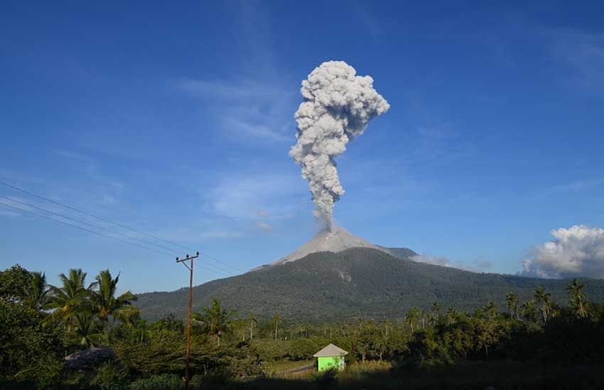

Nusa Tenggara, Indonesia Sentinel — Indonesia’s Mount Lewotobi Laki-Laki, located in East Nusa Tenggara, erupted early Wednesday (Dec. 18, 2024) at 5:01 AM local time, marking its third eruption in a week. The heightened activity has raised concerns among local communities and authorities, with the volcano now under a Level IV (Awas) alert, the highest on Indonesia’s volcanic monitoring system.
According to the Center for Volcanology and Geological Hazard Mitigation (PVMBG), the eruption sent an ash column 300 meters above the volcano’s summit, reaching an altitude of 1,884 meters above sea level. The ash plume was observed to be thick and gray, drifting northward. Seismic monitors recorded an eruption amplitude of 14.8 millimeters lasting 96 seconds.
A Year of High Volcanic Activity
Mount Lewotobi Laki-Laki is one of Indonesia’s most active volcanoes in 2024, with 979 eruptions recorded this year. Indonesia, part of the Pacific “Ring of Fire,” experiences frequent volcanic and seismic activity due to its location at the convergence of multiple tectonic plates.
Data from PVMBG’s MAGMA Indonesia platform shows that 5,974 volcanic eruptions have occurred across the country this year. Among these, Mount Ibu in North Maluku leads with 2,471 eruptions, followed closely by Mount Lewotobi Laki-Laki.


Increased Seismic Activity
Seismic observations during the night leading up to the eruption revealed elevated activity. Between 6:00 PM and 11:59 PM local time, PVMBG recorded:
- Two eruption tremors, with amplitudes between 2.9 and 5.9 millimeters, lasting 15–17 seconds.
- Six harmonic tremors, with amplitudes of 3.7–10.5 millimeters and durations ranging from 14 to 266 seconds.
- One deep volcanic quake, measuring an amplitude of 4.4 millimeters with a duration of 13 seconds.
These indicators suggest ongoing magma movement beneath the volcano, raising concerns about potential future eruptions.
Safety Precautions and Evacuation Zones
Authorities have issued warnings to residents and tourists, advising against any activities within a 6-kilometer radius of the eruption site. Additional restrictions apply to sectors extending 7 kilometers from the crater in the southwest, north, and northeast directions due to the risk of pyroclastic flows and falling volcanic debris.
PVMBG has also urged local communities to stay vigilant, especially near river valleys originating from the volcano. These areas are at heightened risk of lahar flows, a dangerous mix of volcanic material and water triggered by rainfall.
Impacts on Local Communities
Mount Lewotobi Laki-Laki’s eruptions pose challenges for local communities, many of whom rely on agriculture for their livelihoods. Ashfall can damage crops and contaminate water supplies, compounding the difficulties faced by residents in this remote region.
Despite the risks, Indonesia has developed robust disaster management protocols. The country’s volcano monitoring network and emergency response teams have been instrumental in mitigating the impact of volcanic events.
Indonesia’s Mount Semeru Erupts, Sending Ash 1,000 Meters into the Sky
Global Relevance
Volcanic activity in Indonesia has significant implications for global research on geology and climate. Large eruptions can release vast amounts of ash and gases into the atmosphere, potentially influencing weather patterns and air travel.
As Mount Lewotobi Laki-Laki continues its unrest, scientists and disaster management teams remain on high alert, closely monitoring the situation to safeguard communities and minimize the potential for disaster.
(Becky)


