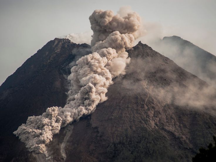

Yogyakarta, Indonesia Sentinel — Mount Merapi, located in Sleman Regency, Yogyakarta, remains closed for hiking activities due to ongoing volcanic risks and climbers safety reasons. As of early 2025, the most active volcano status remains at Level III (Alert), unchanged since 2018.
Despite being a favorite destination for tourists, particularly during year-end celebrations, Mount Merapi remains off-limits for climbers, due to safety concerns.
The Mount Merapi National Park Agency (BTNGM) reaffirmed this closure in an Instagram post on December 4, stating, “We would like to remind everyone that hiking routes to Mount Merapi, including the Selo and Sapu Angin trails, remain CLOSED.”
No specific timeline has been provided for reopening, with the agency stating the closure will remain in effect “until further notice.”


To ensure climbers safety, authorities continue to patrol and monitor access points to prevent unauthorized entry. Hiking will only be permitted once volcanic activity returns to Level I (Normal), following recommendations from the Geological Disaster Technology Research and Development Center (BPPTKG) in Yogyakarta.
Hiking Routes on Mount Merapi
Mount Merapi has two primary hiking trails: the Selo Trail and the Sapu Angin Trail. Both routes lead to Pasar Bubrah, an area less than one kilometer from the summit.
Currently, Mount Merapi remains at Alert Level III, with ongoing volcanic activity, including pyroclastic flows and lava emissions. BPPTKG advises maintaining a safe distance of 3 kilometers from the summit on the northern and eastern sides.
Therefore, access to both the Selo and Sapu Angin trails will remain closed indefinitely to ensure the safety of climbers and visitors.
Illegal Climbers Report
Despite being closed, the Mount Merapi National Park Agency (TNGM) revealed that throughout 2024, several unauthorized attempts to climb the mountain have been detected.
These attempts involved both local hikers and foreign nationals. According to TNGM records, there have been nine recorded incidents of illegal climbing attempts in 2024. The majority involved foreign nationals who primarily attempted to access the mountain via the Selo route in Boyolali.
Some climbers were intercepted by park authorities before starting their ascent and were ordered to turn back, due to concerns over climbers safety. However, others managed to reach the summit before being discovered.
Authorities continue to emphasize the extreme dangers posed by Mount Merapi’s ongoing volcanic activity and urge the public to comply with safety restrictions to prevent accidents or casualties.
Recent Mount Merapi Activity
According to Detik, The Geological Disaster Technology Research and Development Center (BPPTKG) in Yogyakarta issued a periodic early warning in January 2025, emphasizing that Mount Merapi remains highly hazardous up to this day. The warning follows over seven hours of continuous rainfall on January 5, which increased the risk of volcanic material being dislodged from the summit area.
Agus Budi Santoso, Head of BPPTKG DIY stated that high rainfall poses a significant threat to climbers, as the unstable crater structure could trigger landslides of volcanic material. Rainwater could further exacerbate this risk by carrying loose debris downslope.
Read also : Mount Merapi Volcano Report: Over 1,500 Tremors and Lava Movement
Additionally, on Saturday, January 4, 2025, Merapi recorded 28 lava flows toward the southwest, specifically along the Bebeng and Krasak Rivers, with a maximum flow distance of 1,600 meters. Highlighits mountain conditions which is still active and very dangerous.
Hazard Potential Remains High
As Mount Merapi remains at Alert Level III (Siaga), BPPTKG warns that volcanic activity, including incandescent lava flows, pyroclastic flows, and explosive ejections of volcanic material could occur at any time.
Some danger prone areas including:
- Southwest Sector: Potential lava and pyroclastic flows could reach up to 5 kilometers along the Boyong River and up to 7 kilometers along the Bedog, Krasak, and Bebeng Rivers.
- Southeast Sector: Flows could extend 3 kilometers along the Woro River and 5 kilometers along the Gendol River.
- Explosive Ejections: Volcanic material from explosive eruptions could be thrown up to 3 kilometers from the summit.
Monitoring data also indicate a continued supply of magma, increasing the likelihood of pyroclastic flows within designated hazard zones.
Public Advisory
BPPTKG strongly urges the public to refrain from entering hazardous zones and to remain vigilant for lahars and pyroclastic flows, especially during heavy rainfall near Mount Merapi. Thus, any significant changes in volcanic activity will prompt an immediate review of the current alert level.
Due to safety issue, authorities keep on reminding the public, particularly climbers, that Mount Merapi remains closed to all hiking activities via any route until further notice. Compliance with safety regulations is essential to prevent accidents and loss of life.
(Raidi/Agung)


